Improving mobility in the age of smart and inclusive cities
Mir Abolfazl Mostafavi and his team are using geospatial technologies and intelligence to make life easier for people with disabilities by facilitating mobility and improving access to the environment.
Project architect
Mir Abolfazl Mostafavi, Eng., PhD.
- Full Professor, Department of Geomatic Sciences, Faculty of Forestry, Geography and Geomatics
- Director, Mobility Sensing Lab (Mobility Sensing Lab)
Affiliated with:
- Centre de recherche en données et en Intelligence géospatiale (CRDIG)
- Centre interdisciplinaire de recherche en réadaptation et en intégration sociale (CIRRIS)
Member of:
- Institut sur le vieillissement et la participation sociale des ainés (IVPSA)
- Institut Hydro-Québec en environnement, développement et société (Institut EDS)
- Centre québécois de recherche sur la gestion de l'eau (CentrEau)
Team
Through his projects, Dr. Mostafavi works closely with students and colleagues from various disciplines at CRDIG, CIRRIS, IVPSA, CentrEau, and Institut EDS.
Partenaires
- Ville de Québec
- Centre intégré universitaire de santé et de services sociaux de la Capitale-Nationale (CIUSSSCN - IRDPQ)
- Regroupement des organismes de personnes handicapées de la région 03 (ROP 03)
- Réseau de transport de la Capitale (RTC)
- Several industry partners
- Centre de Ressources et d’Innovation Mobilité Handicap (CEREMH), France
Facilitating travel with geospatial mobility assistance technologies (MobiliSIG)
The MobiliSIG project led by Professor Mostafavi, aims to develop mobile geospatial technology that improves the social inclusion and quality of life of people with disabilities by facilitating travel .
The MobiliSIG application allows users to plan accessible routes adapted for people with disabilities to help them get around. The current version of the app takes a social innovation approach and focuses on the mobility of people in wheelchairs, but ongoing research also targets other types of disabilities (visual, auditory, cognitive, etc.).
Improving the experience of humans in their environment
Professor Mostafavi's Mobility Sensing Lab (Mobility Sensing Lab) is funded by the Canada Foundation for Innovation (CFI) to carry out research activities aimed at improving the experience of humans in their environment.
The goal of the lab is to design intelligent and connected environments, to better understand the complex interactions between people, particularly those with disabilities, and their environment, and to design and develop new generations of geospatial tools to improve spatial mapping of human activities (sense of place).
Using geospatial intelligence in health care and sustainable development
Professor Mostafavi and his team have been working for several years in collaboration with multidisciplinary teams to develop geospatial decision support tools in the field of health and sustainable development.
Recent projects include the use of sensor networks and the Internet of Things to model and analyze energy efficiency in buildings, the development of a geospatial decision support system to optimize the organic waste recovery chain (Optim-O), and the application of mobile lidar technology for the safe exploitation of underground mining resources (MinEyes).

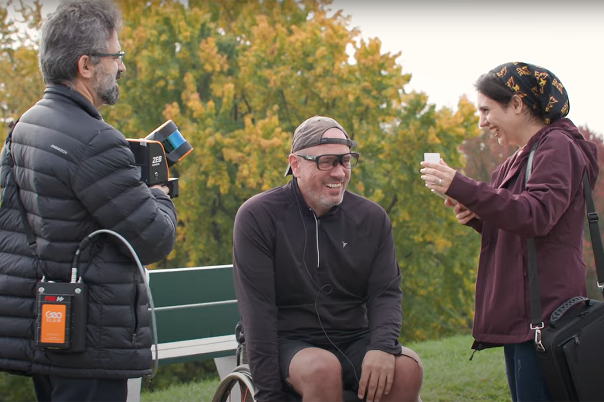
Using the MobiliSIG app to make it easier for wheelchair users to get around.

Using state-of-the-art technology to obtain detailed and accurate environmental accessibility data.

Analyzing and understanding the interactions of humans with their environment using biometric sensors.

Creating smart environments to help people with disabilities get around.
What’s next
Research continues at the Mobility Sensing Lab to design and implement innovative and inclusive geospatial assistance solutions that will facilitate the mobility of people with disabilities and the elderly.
These solutions are based on an ecosystem approach and the principles of social innovation, and will be organized around three areas of research:
- Creating smart and inclusive environments from an ecological perspective.
- Understanding the complex interactions of humans with their physical, social, and technological environment to better support people with disabilities, with or without technical assistance, for all forms of disabilities, whether physical, sensory, cognitive, or intellectual.
- Designing and developing geospatial assistance technologies and their application in collaboration with laboratory partners.
Université Laval au cœur de nos vies
Podcast
Learn more about geospatial technologies and their practical applications by listening to this interview with Mir Abolfazl Mostafavi, hosted by Valérie Gaudreau, editor-in-chief of Le Soleil (in French).
Listen to the podcastULaval News article (in French)
Learn about Mir Abolfazl Mostafavi’s background, his research results, and the real difference his work makes in the lives of people with physical disabilities.
Read the ULaval News article (in French)